This Satellite Liaison Blog showcases the use of satellite imagery to monitor storms, including the experimental OCTANE Speed Sandwich product, as well as diagnosing fog, using the Nighttime Microphysics RGB.
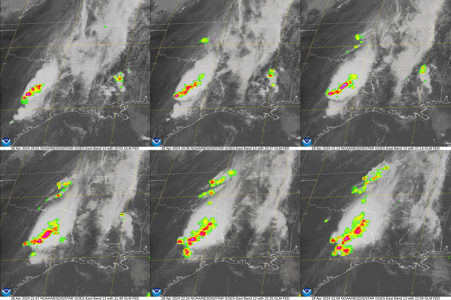
Heavy rain and severe thunderstorms hit the Southern Plains during the last weekend of April as moist, southerly air streamed northward from the Gulf of Mexico while a slow-moving cold front and dryline set up across central Oklahoma and Texas. GOES-East 1-minute mesoscale Channel 13 10.3 um imagery overlaid with the Geostationary Lightning Mapper (GLM) Flash Extent Density (FED) showcased widespread storms across eastern Oklahoma and Texas from 2000 UTC to 2300 UTC 28 April 2024.
Figure 1: GOES-East GLM FED overlaid on Channel 13 10.3 um imagery as storms fired across easter Texas and Oklahoma. Credit: NESDIS/STAR
The Experimental Octane Speed Sandwich Product provides information on cloud motions using GOES Channel 2 0.64 um imagery during the day and Channel 13 imagery at night. Large changes in speed, noted by rapidly changing colors, can indicate convective initiation, which was widespread across the Southern Plains from 2000 UTC to 2300 UTC 28 April 2024. The Octane product is available for mesoscale sectors only.
Figure 2: The GOES-East Octane Speed Sandwich product shows rapidly changing speed values, indicating the presence of shear as storms persist in Texas and fire in Oklahoma. Imagery can be accessed on the CIRA Slider
GOES-East Channel 13 imagery also helped diagnose the maintenance of a large storm complex over eastern Texas and Louisiana, prompting a Mesoscale Precipitation Discussion (MPD) to be issued by the Weather Prediction Center (WPC) on 0245 UTC 29 April 2024. From NWS WPC, in the late PM of 4/28: “GOES-E IR satellite imagery shows a very strong cold-topped convective wedge signature over southeast TX with persistent areas of backbuilding and training showers and Thunderstorms.”
Figure 3: GOES-East Channel 13 IR imagery used in the WPC MPD over Texas and Louisiana late during the evening of 28 April 2024.
The Multi-Radar Multi-Sensor System (MRMS) Quantitative Precipitation Estimate (QPE) 24-hour product showed widespread rainfall amounts of over 2 inches across eastern Texas and Oklahoma with isolated pockets of over 8 inches leading up to 0300 UTC 29 April 2024.
Figure 4: MRMS 24-hour QPE data valid 0300 UTC 29 April 2024 shows heavy rainfall across the Southern Plains.
The NASA-SPoRT Below Land Surface Relative Soil Moisture Percentiles product relies on precipitation analyses, vegetation, and the NCEP/EMC North American Land Data Assimilation System phase 2 (NLDAS-2) for data sources. Percentiles were in excess of 80 percent over much of the eastern Southern and Central Plains on 0000 UTC 29 April 2024, as soils were extremely saturated after days of heavy rainfall.
Figure 5: NASA SPoRT Below Land Surface Relative Soil Moisture Percentiles shows a gradient of dry soils in western and central Oklahoma to very wet soils to the east.
By 0720 UTC 29 April 2024, JPSS Nighttime Microphysics RGB imagery, with its high resolution of 750 m, showed fog beginning to develop west of storms in eastern Texas and Oklahoma. The Nighttime Microphysics RGB helps to depict fog during nighttime by combining infrared channels and is depicted by dull aqua-gray colors.
Figure 6: JPSS Nighttime Microphysics RGB imagery valid 0720 UTC showing fog developing to the west of storms in Texas and Oklahoma. Imagery can be accessed on the CIRA Slider
By 1130 UTC 29 April 2024, Dense Fog Advisories spanned from the Dallas-Fort Worth metro area to northwestern Arkansas and southwestern Missouri.
Figure 7: National Weather Service (NWS) alerts in effect across the Continental U.S. valid 1135 UTC 29 April 2024.
Fog in the GOES-East animation can be seen by the nearly stationary dull aqua-gray colored features across eastern Texas and Oklahoma from 1000 to 1200 UTC 29 April 2024.
Figure 8: GOES-East Nighttime Microphysics RGB imagery valid ~1000 UTC to ~1200 UTC 29 April 2024. This animation was created in AWIPS, and display files can be shared on request.
Station observations where the fog was located had visibility down to a quarter of a mile and the WPC Surface Analysis on 1200 UTC 29 April 2024 showed fog at stations south of a cold front draped across southern Oklahoma.
Figure 9: NWS station observations showing low visibilities where Dense Fog Advisories were in place in Texas, Oklahoma, and Missouri.
Figure 10: WPC Surface Analysis valid 1200 UTC 29 April 2024.
According to the Storm Prediction Center, there were over 300 storm reports between 27 and 28 April 2024. The WPC had also issued a High Risk of Excessive Rainfall on Saturday, 27 April 2024, across portions of east-central Oklahoma for widespread flash flooding.
Chris Smith, CISESS GOES-R Satellite Liaison for NWS WPC/OPC


