The GOES-East Sea Spray RGB captured sea spray in the southern and eastern quadrants of a storm-force low in the Western Atlantic on 23 April 2024. The Sea Spray RGB depicts sea spray by combining visible and infrared (IR) bands and is available for the GOES-East, GOES-West, Himawari-9, Meteosat-9/10, and JPSS satellites. Sea spray can reduce visibilities for vessels and can also cause icing in a favorable environment.
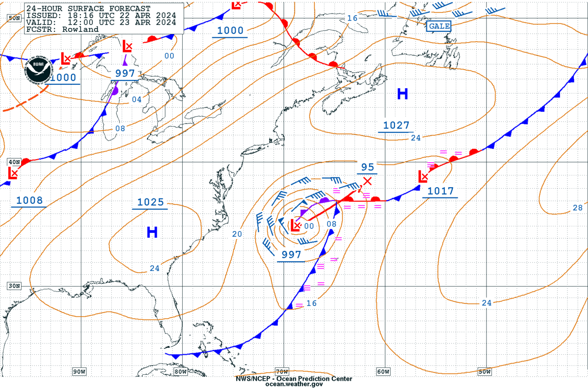
The West Atlantic 24 Hour Surface Forecast issued by the Ocean Prediction Center (OPC) on 22 April 2024 showed a 997 mb low pressure in the west-central Atlantic at 1200 UTC 23 April 2024.
Figure 1: OPC West Atlantic 24-Hour Surface Forecast valid 1200 UTC 23 April 2024.About 20 hours later, a Metop-B ASCAT pass helped confirm that the extratropical system had storm-force winds in excess of 48 kt in the western quadrants around 1400 UTC 23 April 2024.
Figure 2: A Metop-B ASCAT pass at ~1400 UTC 23 April 2024 confirms storm-force winds in the system’s western quadrants.
GOES-East Sea Spray RGB imagery identified sea spray, first in the southern quadrant of the low pressure before shifting to the eastern quadrant from ~1200 UTC to 1630 UTC 23 April 2024. Sea spray is indicated by the mid-cyan color, which evolves into cloud streets downstream (bright white colors).
Figure 3: 23 April 2024 GOES-East Sea Spray RGB imagery shows sea spray first in the low pressure’s southern quadrant (blue circled area) and then in the eastern quadrant (pink circled area). Imagery can be access on the CIRA Slider.
GOES-East Airmass RGB imagery between 1200 UTC and 1800 UTC 23 April 2024 showed the system strengthening as the extratropical cyclone was in an environment with high levels of potential vorticity, indicated by the dark red and orange colors. The associated cold front can also be seen pushing to the east.
Figure 4: 23 April 2024 GOES-East Airmass RGB imagery showing the storm-force extratropical cyclone off the Mid-Atlantic Coast. Credit: NESDIS/STAR
GOES-East GeoColor during the same timeframe also provided an evolution of the intensifying low pressure with the circulation easily visible.
Figure 5: 23 April 2024 GOES-East GeoColor imagery shows the spinning circulation of the storm-force low pressure. Credit: NESDIS/STAR
OPC Surface Analysis on 1800 UTC 23 April 2024 showed a storm-force low with a minimum central pressure of 995 mb in the western-central Atlantic.
Figure 6: OPC Surface Analysis valid 1800 UTC 23 April 2024.Unfortunately for this event, the JPSS VIIRS pass was contaminated by sun glint for a higher-resolution view of the sea spray. Thank you to Bill Line from NESDIS/STAR for contributing to the Sea Spray RGB information.The Metop-B ASCAT pass was exported from AWIPS. The Sea Spray RGB is not yet in AWIPS, but hopefully will be soon to aid OPC operations.Chris Smith, CISESS GOES-R Satellite Liaison for NWS WPC/OPC


