GOES-East Proxyvis captured low-level cloud features in the North Atlantic on 08 April 2024. Proxyvis mimics visible imagery at night by combining several infrared (IR) bands and is available for the GOES-East, GOES-West, Himawari-9, and Meteosat-9/10 satellites. Low-level cloud features at night over the ocean can be easier to track using Proxyvis rather than traditional IR imagery.
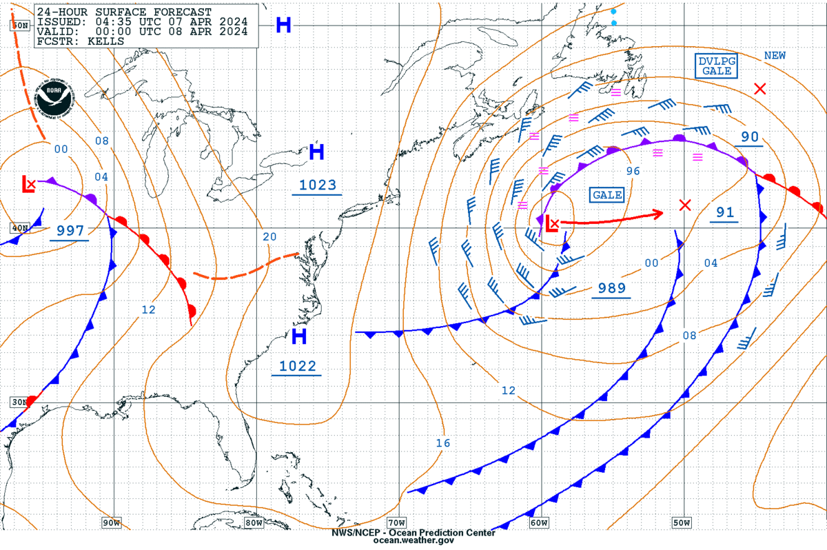
The West Atlantic 24 Hour Surface Forecast issued by the Ocean Prediction Center on 07 April 2024 indicated the potential for fog south of Nova Scotia and Newfoundland on the northern and western flanks of a gale-force storm system at 0000 UTC 08 April 2024.
Figure 1: OPC West Atlantic 24-Hour Surface Forecast valid 0000 UTC 08 April 2024.
The GOES-East Nighttime Microphysics RGB confirmed that from 0000 UTC to 0450 UTC 08 April 2024, an area of low-level clouds and fog persisted south of Newfoundland, indicated by the dull aqua-gray colors and nearly stationary cloud features.
Figure 2: 08 April 2024 GOES-East Nighttime Microphysics RGB showing the fog (circled in white) south of Newfoundland on the northern side of an extratropical cyclone. Credit: NESDIS/STAR
The GOES-East Proxyvis also showed the stagnant low-level cloud features over the ocean (in the blue circled area), with a grayscale color bar that mimics daytime visible imagery. Two cold fronts to the southeast of the low pressure are also seen pushing east into the Central Atlantic waters.
Figure 3: 08 April 2024 GOES-East Proxyvis displays the low-level clouds and fog south of Newfoundland, as well as two cold fronts to the south and east (purple arrows highlighting cold fronts). Imagery can be accessed on the CIRA Slider.
Meanwhile, the low-level cloud features are much more difficult to detect when using the traditional GOES-East Clean Longwave Window IR channel, as low-level clouds look to be mostly identical with the same gray color.
Figure 4: 08 April 2024 GOES-East Clean Longwave IR (Band 13) imagery doesn’t detect the fog and low-level cloud features as well as Proxyvis. Credit: NESDIS/STAR
The JPSS/VIIRS Nighttime Microphysics RGB showed the low level clouds persisting on the northwest flank as the extratropical cyclone pulled away from Nova Scotia and Newfoundland around 0600 UTC 08 April 2024.
Figure 5: 08 April 2024 JPSS/VIIRS Nighttime Microphysics RGB shows low clouds persisting on the extratropical cyclone’s northern and western flanks around 0600 UTC. Credit: CIRA Slider
GOES-East, GOES-West, Himawari-9, and Meteosat-9/10 Proxyvis are now all available in AWIPS-II workstations at OPC.
Chris Smith, CISESS GOES-R Satellite Liaison for NWS WPC/OPC


![Reconstructing the approximate reentry and disintegration position of Starship FT3 [UPDATED]](https://astrosci.info/wp-content/uploads/2024/06/STARSHIP_FT3_14March2024_reentrypoint_estimates_anot.jpg)

